HomeCategory

Northern Circuit

AllNorthern Circuit

Enduimet-Longido Area, a pristine wildlife corridor in northern Tanzania's West Kilimanjaro Basin, beckons intrepid explorers with its untamed Maasai landscapes and cross-border migrations just 100 km from Arusha. This community-managed haven, encompassing the Enduimet Wildlife Management Area (WMA) and Longido District, spans 752–1,282 km² of communal lands bordering Kilimanjaro National Park to the southeast, Kenya to the north, and Ngasurai Open Area to the west—ideal for off-the-beaten-path Tanzania safaris that blend adventure, culture, and conservation in the shadow of Africa's highest peak.

Lake Eyasi Area, a hidden gem in northern Tanzania’s Great Rift Valley, offers an off-the-beaten-path Tanzania safari experience blending indigenous cultures, birdwatching havens, and stark volcanic landscapes just 100 km southwest of Arusha and near Ngorongoro Crater. This seasonal soda lake basin, spanning about 1,050 km² at 1,040 m elevation, captivates with its tropical contrast to surrounding highlands—palm-fringed shores and Hadzabe hunter-gatherer communities—making it ideal for cultural immersion trips alongside Northern Circuit adventures like Serengeti safaris.

Vegetation around Lake Eyasi creates a dramatic, almost tropical oasis amid arid rift plains, featuring doum palms and lush riparian thickets lining the shallow saline waters, interspersed with umbrella thorn acacias, sandpaper bushes, and thorny succulents like Euphorbia ingens for a resilient, low-water biome. During wet seasons, grasses and wild herbs burst into green carpets on the lake bed, while dry periods reveal dusty savannahs dotted with baobabs and medicinal plants, supporting a unique mix of rift-valley flora that thrives in alkaline soils and supports local Datoga pastoralists’ herds.

Weather in the Lake Eyasi Area is intensely hot and arid year-round, with daytime highs of 25–35°C (77–95°F) and cooler 15–20°C (59–68°F) nights, moderated by rift breezes but amplified by the valley floor’s basin effect. The dry season (June–October) brings scant rain and golden, accessible trails for hiking and wildlife spotting as the lake shrinks to mudflats; short rains (November–December) spark brief greening and bird arrivals, while the long wet season (March–May) floods the basin with shallow brackish waters up to several meters deep, turning it lush but muddy—best for birders, though access challenges arise.

Geologically, Lake Eyasi anchors the Eyasi-Wembere branch of the East African Rift, the world’s oldest rift system formed by tectonic divergence over 30 million years ago, where continental plates pull apart at 6–7 mm annually, creating elongated depressions filled by endorheic soda lakes like Eyasi. Volcanic ash from nearby Ngorongoro and Serengeti highlands enriches the saline soils (pH 8–10), while fault-block escarpments rise sharply around the basin; Mumba Cave’s layered sediments reveal ancient rift activity, with no active eruptions but seismic tremors underscoring ongoing continental rifting that shaped this evolutionary cradle.

Key features of the Lake Eyasi Area include its elongated, seasonal soda lake—drying to a vast cracked bed in droughts but swelling with mineral-rich waters during rains—framed by rift escarpments and volcanic plains linking to Serengeti ecosystems. Attractions abound for cultural and nature seekers: immerse with the Hadzabe (Hadza) bushmen on dawn hunting expeditions using bows and arrows, gathering honey and tubers in age-old traditions dating back 10,000 years; visit Datoga villages for blacksmithing demos and vibrant markets like Ghorofani (5th of each month) showcasing beads and crafts. Explore Mumba Rock Shelter, an archaeological site with 130,000-year-old human remains and paintings, or hike escarpment trails for panoramic views; birding walks along palm-shaded shores and boat safaris on flooded waters highlight the area’s biodiversity, while eco-lodges like Lake Eyasi Safari Lodge offer stargazing and tribal storytelling—perfect add-ons to Ngorongoro Crater tours.

In human evolution history, Lake Eyasi Area echoes the “Cradle of Mankind,” with Mumba Cave yielding Homo sapiens fossils from 50,000–130,000 years ago, including tools and burials that illuminate early modern human adaptations to rift environments; nearby Olduvai Gorge (20 km away) extends this legacy with 1.9-million-year-old hominid footprints, underscoring how rift volcanism and lake fluctuations drove bipedalism, migration, and cultural innovation among ancestors like the Hadzabe’s forebears.

Animals in the Lake Eyasi Area focus on resilient rift dwellers rather than big-game spectacles: waterbucks, warthogs, dik-diks, and vervet monkeys around springs; smaller predators like jackals, caracals, hyenas, and mongooses prowl the bush, with occasional giraffes and zebras grazing acacia fringes—lungfish and catfish thrive in the alkaline lake, drawing opportunistic hunters.

Birdlife dazzles with over 350 resident species, turning shores into a Tanzania birdwatching paradise: Fischer’s lovebirds nest in doum palms, while Africa spoonbills, great white pelicans, yellow-billed storks, gray-headed gulls, pied avocets, barbets, weavers, and spur fowls flock to mudflats and waters. Raptors like bateleur eagles soar overhead, and flamingos tint shallows pink during breeding peaks.

Migrating species swell flocks from November–April, with Palearctic waders—Eurasian curlews, sandpipers, and white storks—joining residents for massive congregations on evaporating shores, especially post-rains when the lake’s caustic waters teem with insects and algae, creating seasonal avian flyways in this under-the-radar rift hotspot.

Lengai-Natron Area, a surreal rift-valley wonder in northern Tanzania’s Arusha Region, captivates adventurers with its blood-red alkaline Lake Natron and the sacred Ol Doinyo Lengai volcano—known as the “Mountain of God” to the Maasai. Spanning about 1,000 km² in the Gregory Rift, this remote off-the-beaten-path destination 120 km northwest of Arusha offers uncrowded Tanzania safaris blending extreme geology, flamingo spectacles, and cultural immersion, ideal for hikers, birders, and paleoanthropology enthusiasts seeking authentic East African adventures beyond the Northern Circuit.

Vegetation in the Lengai-Natron Area thrives in harsh, arid conditions, featuring sparse acacia-commiphora woodlands and thorny bushlands dotting the dusty plains around Lake Natron, where salt-tolerant halophytes like samphire and blue-green algae (cyanobacteria) dominate the lake’s crusty shores. Riverine thickets of figs and doum palms line the Ewaso Ng’iro and Engaresero rivers, providing oases amid the semi-desert, while the volcano’s lower slopes support resilient succulents and lichens on black lava fields. Higher elevations near Ol Doinyo Lengai transition to dry montane scrub with aloes and euphorbias, creating a stark, otherworldly mosaic that underscores the area’s resilience in one of Tanzania’s hottest, driest zones.

Weather here is intensely hot and arid year-round, with temperatures averaging 25–35°C (77–95°F) and peaks up to 40°C (104°F) in the lowlands, cooled slightly by rift winds. The dry season (June–October) delivers scorching days and chilly 15°C (59°F) nights with minimal rain (<500 mm annually), concentrating wildlife and turning the lake blood-red from evaporating minerals—perfect for flamingo breeding peaks in August–October. Short rains (November–December) bring brief, erratic showers and lush green bursts, while the long wet season (March–May) sees heavier downpours (up to 900 mm on highlands) greening the bush but flooding shores and muddying tracks; avoid mid-November–February for extreme heat, though January–February offers warm solitude post-calving.

Geologically, the Lengai-Natron Area pulses with East African Rift dynamism, where continental plates pull apart at 3 mm/year along the Natron Fault, fueling Ol Doinyo Lengai’s unique natrocarbonatite eruptions—low-temperature (510°C) black lava rich in sodium and potassium that weathers to white soda-like crusts, the only such activity on Earth. Formed 350,000–400,000 years ago as a stratovolcano rising 2,886 m, Lengai’s dual craters (active northern one) last majorly erupted in 2007–2008, spewing ash over 18 km and causing seismic tremors felt in Kenya, while hot springs bubble minerals into Lake Natron, raising its pH to 10–12 and petrifying carcasses in calcified “stone” sculptures. Tectonic uplift and erosion carve dramatic escarpments, with ancient ash layers enriching alkaline soils for extremophile life.

Beyond its geological drama, the Lengai-Natron Area brims with attractions: Lake Natron’s shallow (3 m deep), 60 km-long soda expanse shifts from crimson to turquoise with seasonal algae blooms, drawing 2.5 million lesser flamingos for nesting on caustic ash islands— a pink avian carpet visible on guided shore walks. Ol Doinyo Lengai’s overnight summit hike (8–12 hours, no technical skills needed) rewards with panoramic crater views and steaming fumaroles, while nearby hot springs offer therapeutic soaks amid geysers. Waterfalls like the Munge Cascades near Olmoti Crater invite refreshing hikes through rift gorges, and Maasai bomas provide cultural encounters with traditional dances, beadwork, and livestock herding. The remote Engare Sero site unveils 400 preserved human footprints (5,000–19,000 years old) etched in volcanic ash, a poignant glimpse into prehistoric migrations along rift trails.

In human evolution history, the Lengai-Natron Area echoes the Cradle of Mankind, its rift valleys preserving early hominid traces amid fossil-rich sediments from 1.8 million years ago, linking to nearby Olduvai Gorge’s Australopithecus and Homo habilis discoveries. Engare Sero’s footprints reveal barefoot hunter-gatherers navigating the volatile landscape, while volcanic activity mirrored the environmental pressures shaping bipedalism and tool use—making this a pivotal paleo-site for understanding Homo sapiens’ rift-born resilience.

Wildlife adapts tenaciously to the caustic terrain, with zebras, wildebeest, and giraffes grazing acacia fringes, alongside eland, gerenuk, and dik-diks evading leopards and hyenas in bushlands, while Maasai lions occasionally prowl. The area lacks Big Five density but hosts resilient species like tilapia in spring-fed shallows.

Birdlife explodes with over 500 species, residents including lesser flamingos (75% of global population breeding here), pelicans, and fish eagles dominating the lake, joined by ground hornbills, violet wood-hoopoes, and Shelley’s starlings in thorn scrub. Raptors like long-crested eagles and bateleurs patrol skies. Migratory Palearctic waders—up to 100,000 Eurasian curlews, sandpipers, and white storks—arrive November–April, swelling flocks on evaporating mudflats for a migratory spectacle in this flamingo haven.

Ngorongoro-TWE-4
Ngorongoro-TWE-3
Ngorongoro-TWE-2
Ngorongoro-TWE-1
Ngorongoro-TWE-9
Ngorongoro-TWE-19
Ngorongoro-TWE-14
Ngorongoro-TWE-24
Ngorongoro-TWE-44
Ngorongoro-TWE-46
Ngorongoro-TWE-40
Ngorongoro-TWE-27

Ngorongoro Conservation Area

The Ngorongoro Conservation Area is one of Africa’s most iconic safari destinations. It is a UNESCO World Heritage Site known for its rich wildlife, dramatic landscapes, and cultural heritage.

Located about 180 km west of Arusha, this vast protected area covers 8,292 km². It blends wildlife conservation with Maasai pastoral life and world-renowned archaeological sites.

At its center lies the legendary Ngorongoro Crater, the largest intact volcanic caldera in the world.

Plan your Ngorongoro safari with The Woven Experience and explore Tanzania’s most breathtaking landscapes.

Landscape and Natural Features

Ngorongoro’s landscapes are incredibly diverse. They range from lush highlands to open plains.

The crater floor is dominated by short-grass savannah and seasonal wetlands. Fever trees and acacias surround Lake Magadi.

The crater rim rises between 2,200 and 3,600 meters. It is covered in dense montane forest with moss and lichen.

Beyond the crater, the highlands open into rolling grasslands and volcanic formations. These stretch toward Serengeti National Park.

Discover these breathtaking landscapes on a customized safari itinerary.

Vegetation and Ecosystems

Vegetation in Ngorongoro changes with altitude. Each zone supports unique wildlife.

The crater floor hosts nutrient-rich grasslands ideal for grazing animals.

Lerai Forest provides groundwater-fed vegetation. It offers shelter to elephants and leopards.

The highlands feature moorlands with giant lobelias and red-hot pokers.

Montane forests on the crater rim include croton, olive, and podocarpus trees.

Explore diverse ecosystems in one destination with our expert-guided safaris.

Climate and Best Time to Visit

Ngorongoro has a cool highland climate. The weather varies between the crater floor and rim.

The dry season runs from June to October. Days are clear, and wildlife viewing is excellent.

The short rains occur from November to December. Landscapes become green and vibrant.

The long rainy season is from March to May. This period offers lush scenery and fewer visitors.

January and February bring warmer weather and the calving season.

Contact us to choose the best time for your Ngorongoro adventure.

Geological Formation

Ngorongoro formed around 2–3 million years ago. A massive volcano collapsed after an eruption.

This created the vast caldera seen today. Its scale rivals Mount Kilimanjaro.

The area lies within the Great Rift Valley. Geological activity continues to shape the region.

Nearby volcanic features include Olmoti Crater and Empakaai Crater.

Experience one of Earth’s most fascinating geological landscapes.

Key Attractions

Ngorongoro offers more than just the crater. The surrounding region is rich in natural and cultural sites.

Olduvai Gorge is known as the “Cradle of Mankind.” It holds some of the earliest human fossils.

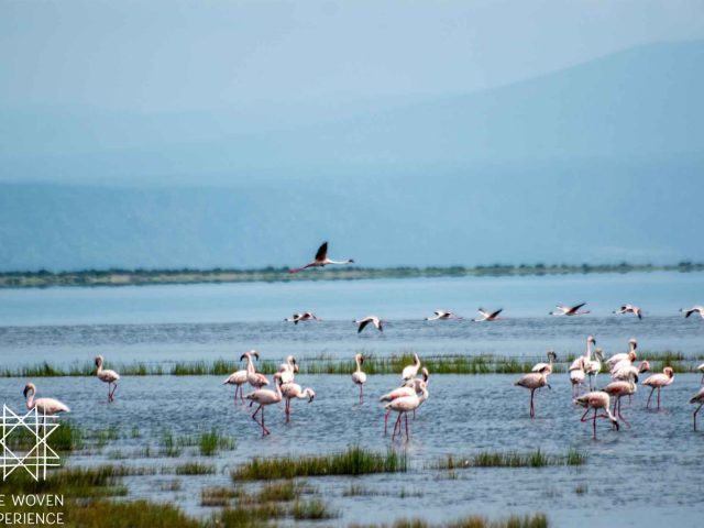
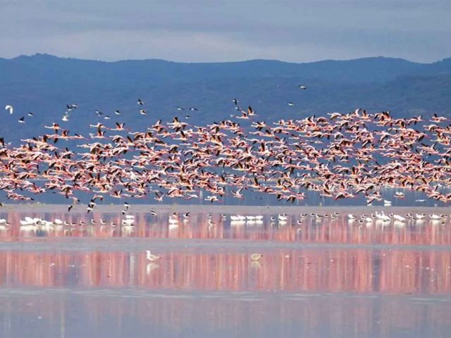
Empakaai Crater features a deep soda lake filled with flamingos.

Olmoti Crater offers scenic hiking trails and waterfalls.

Views from the highlands extend to Ol Doinyo Lengai, an active volcano.

Add these unique experiences to your safari itinerary today.
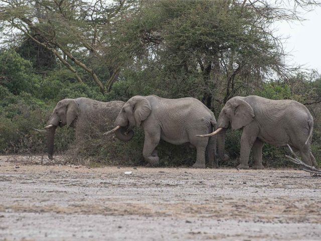
Wildlife

Ngorongoro is one of the best places in Africa for wildlife viewing.

The crater supports over 25,000 large animals year-round.

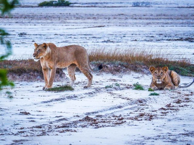
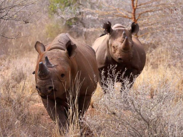
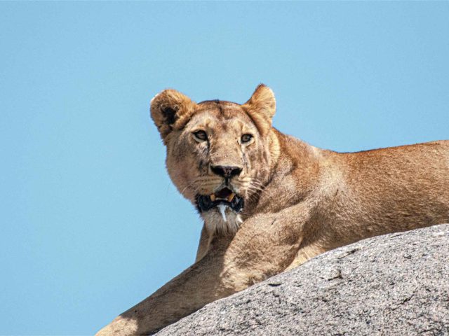
You can see lions, elephants, buffalo, and the endangered black rhino.

Wildebeest and zebras graze across the plains. Predators such as hyenas and jackals are common.

The area connects ecologically with the Serengeti ecosystem.

Book your safari for unforgettable Big Five encounters.

Birdlife

Ngorongoro is a top birding destination with over 500 species recorded.

Lake Magadi attracts large flocks of flamingos.

Ostriches roam the plains, while forest species thrive on the crater rim.

Birds of prey, including eagles and buzzards, soar above the crater.

Migratory birds arrive between November and April.

Join a birding safari and experience Ngorongoro’s incredible avian diversity.
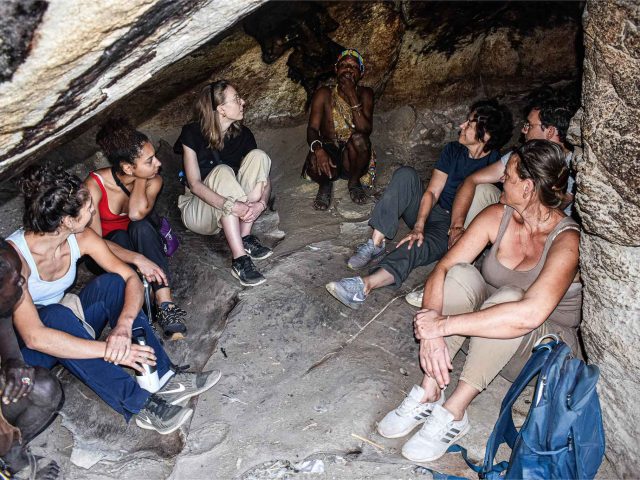
Maasai Culture

The Ngorongoro Conservation Area is unique for its coexistence of people and wildlife.

The Maasai communities continue their traditional pastoral lifestyle here.

Visitors can explore Maasai bomas and learn about their culture and traditions.

This cultural connection adds depth to every safari experience.

Enhance your journey with authentic cultural experiences.

Plan Your Ngorongoro Safari

Ngorongoro offers a complete safari experience in one destination. It combines wildlife, landscapes, and culture.

Whether you seek luxury or adventure, this destination delivers unforgettable moments.

Start planning your Ngorongoro safari with The Woven Experience today. Let us craft your perfect itinerary.

Saadani National Park, Tanzania’s only coastal wildlife sanctuary spanning 1,100 km² along the Indian Ocean, blends bush, beach, and river adventures just 130 km north of Dar es Salaam. This East African gem, established in 2005, offers a rare fusion of marine and terrestrial ecosystems where elephants roam sandy shores and green turtles nest under starry skies—perfect for eco-tourists seeking Tanzania safaris with a seaside twist. Nestled in the historic Bagamoyo-Pangani-Zanzibar triangle, Saadani’s diverse habitats draw adventurers for boat cruises on the Wami River, guided walks amid ancient ruins, and sunset swims, making it an ideal extension to Zanzibar beach holidays.

Vegetation in Saadani National Park transitions seamlessly from palm-fringed white-sand beaches and tidal mangrove forests along the coastline—vital nurseries for prawns and fish—to lush riparian zones with massive sycamore figs and riverine thickets along the Wami River. Inland, open grasslands dotted with acacia thickets and scattered palms dominate the humid savannah, while former sisal plantations yield short-grass grazing lands and black cotton plains with clay-rich soils. Zaraninge Forest’s coastal woodlands shelter rare black-and-white colobus monkeys, creating a biodiversity hotspot where salt-tolerant mangroves protect against erosion and support unique intertidal life.

Saadani’s tropical climate is hot and humid year-round, with average temperatures of 25–27°C (77–81°F) and highs up to 30°C (86°F), cooled by ocean breezes. The dry season (June–October) brings minimal rain, thinning vegetation for prime game viewing and comfortable beach days at 20–24°C (68–75°F) evenings. Short rains (November–December) deliver brief afternoon showers and migratory bird influxes, while the long wet season (March–May) greenses the plains with heavier downpours but fewer crowds—ideal for lush scenery, though roads may muddle. January–February offers warm, variable weather with calving season bonuses and fewer tourists.

Geologically, Saadani lies on Tanzania’s coastal plain, shaped by ancient rift valley extensions and Pleistocene sea-level fluctuations that formed its sandy beaches and estuarine deltas. The Wami River’s meandering path carves fertile floodplains from sedimentary deposits, while mangrove swamps thrive in subsiding tidal zones influenced by the Indian Ocean’s monsoon-driven currents. No active volcanism here, but historical coastal uplift and erosion reveal Swahili ruins from slave-trade eras, with stable Precambrian basement rocks underpinning the park’s resilient, low-relief terrain.

Wildlife in Saadani National Park thrives in this coastal mosaic, with about 30 large mammal species including elephants wandering beaches, giraffes browsing acacias, and buffalo herds on grasslands. Lions, leopards, and spotted hyenas prowl the bush, while warthogs, zebras, wildebeests, hartebeests, waterbucks, reedbucks, greater kudus, elands, sable antelopes, and red duikers graze openly; hippos and Nile crocodiles bask in Wami River pods, joined by yellow baboons, vervet monkeys, and elusive black-and-white colobus in forested patches.

Birders delight in Saadani’s 220+ species, a coastal avifauna paradise with residents like the mangrove kingfisher, giant kingfisher, ground hornbills, woolly-necked storks, bateleur eagles, lanner falcons, long-crested eagles, and African skimmer flitting through mangroves and riverbanks. Flamingos and fish eagles patrol waterways, while turacos and trogons add forest color. Migratory Palearctic shorebirds arrive November–April, including Eurasian oystercatchers, sandpipers, common greenshanks, and other waders probing tidal flats, swelling flocks for spectacular seasonal displays in this underrated Tanzania birdwatching haven.

Mkomazi National Park, Tanzania’s vast 3,245 km² semi-arid wilderness in the northeast, borders Kenya’s Tsavo West National Park, forming the expansive Mkomazi-Tsavo ecosystem—one of East Africa’s largest protected areas. Tucked between the Pare and Usambara Mountains with occasional glimpses of Mount Kilimanjaro, this underrated safari destination draws adventurers to its open nyika bush, ancient baobab silhouettes, and rocky hills, ideal for uncrowded wildlife viewing and cultural immersion in Tanzania’s hidden gems.

Dominating the landscape is Acacia-Commiphora woodland, Tanzania’s signature dry-country vegetation, blending thorny acacias, resinous commiphoras, and grey-green shrubs across vast savannahs. Riverine forests along the Umba River feature lush figs, syzygium, and palms, while western slopes transition to dryland forests and scrublands teeming with over 1,500 plant species—more than 50% endemic to this Somali-Maasai biome, creating a resilient mosaic that thrives in low-rainfall conditions.

Mkomazi’s semi-arid climate follows a bimodal pattern: the prime dry season from June to October brings warm days of 25–30°C (77–86°F) and cooler nights around 15°C (59°F), thinning vegetation for optimal game spotting as animals cluster at scarce waterholes like Dindira Dam. Short rains (November–December) and the longer wet season (March–May) usher in 20–28°C (68–82°F) temperatures with afternoon showers, greening the plains and enhancing scenic beauty, though tracks may turn muddy—perfect for birders chasing migratory arrivals.

Geologically, Mkomazi anchors the East African Rift’s eastern branch, where tectonic shifts formed the Pare-Usambara fault-block mountains through uplift and erosion, framing the park’s dramatic escarpments and valleys. Ancient Precambrian basement rocks underpin the arid soils, while seasonal rivers like the Umba carve riparian corridors; no active volcanism here, but rift-related seismicity subtly shapes the undulating terrain, fostering isolated habitats that boost biodiversity in this transitional Sahel-savannah zone.

Wildlife highlights include endangered black rhinos in the fenced sanctuary—rebuilt from near-extinction—and packs of elusive African wild dogs, alongside the Big Five (lions, leopards, elephants, buffaloes, rhinos). Herds of giraffes, zebras, wildebeest, eland, lesser kudu, gerenuk, fringe-eared oryx, and Grant’s gazelles roam the plains, with cheetahs, hyenas, and jackals adding predatory thrill; over 78 mammal species thrive, though densities are lower than in busier parks, rewarding patient explorers.

Birders revel in Mkomazi’s 450+ species, a dry-country hotspot with residents like the striking vulturine guineafowl, ostrich, kori bustard, secretary bird, southern ground hornbill, violet wood-hoopoe, Friedmann’s lark, and Shelley’s starling flitting through acacias. Raptors such as martial eagles and long-crested eagles patrol the skies, while riverine zones host kingfishers and hoopoes. Migratory Palearctic visitors, including the vivid Eurasian roller, white storks, and pallid harriers, flood in from November to April, swelling flocks and turning wetlands into a seasonal avian extravaganza for Tanzania birdwatching tours.

Kilimanjaro National Park, a UNESCO World Heritage Site encompassing 1,688 km² around Africa’s highest peak at 5,895 m, delivers a “world in one mountain” trek from equatorial rainforest to arctic summit. Located 300 km south of the equator and 50 km from Arusha, the park protects Mount Kilimanjaro’s three volcanic cones—Shira (extinct), Mawenzi (dormant), and Kibo (dormant with fumaroles). Vegetation belts ascend in perfect succession: cultivated foothills (800–1,800 m) give way to dense montane rainforest (1,800–2,800 m) dripping with moss and giant heather; heath and moorland (2,800–4,000 m) feature lobelia decks and everlasting flowers; alpine desert (4,000–5,000 m) hosts hardy lichens; and the glacial summit zone (above 5,000 m) holds permanent ice fields shrinking due to climate change.

Weather on Kilimanjaro varies by altitude and season: climbers target the dry windows of January–February and June–October for 20–25°C (68–77°F) at base and –10°C (14°F) at the summit with minimal precipitation. Short rains (November–December) bring afternoon showers below 3,000 m, while the long wet season (March–May) delivers heavy cloud and snow above 4,000 m, often closing routes. Night temperatures plummet year-round, demanding layered clothing and summit gloves.

Geologically, Kilimanjaro is a stratovolcano formed 750,000 years ago through rift-related eruptions; Kibo’s Reusch Crater still emits sulfurous gases from inner vents, and the Ash Pit reveals 400 m of layered lava. Glaciers like Rebmann and Furtwängler calve dramatically, while radial valleys (barrancos) carved by ancient lava flows guide trekking routes. Seismic monitoring confirms minor activity, but no eruptions since 360,000 years ago.

Wildlife adapts to altitude: blue monkeys, black-and-white colobus, and olive baboons forage in the rainforest alongside bushbabies and tree hyrax. Higher up, eland, Abbott’s duiker, and four-striped mice appear in moorland, with white-necked ravens and alpine chats circling the summit. No large predators roam the upper zones, enabling safe hiking.

Over 180 bird species reside across zones. Rainforest hosts silvery-cheeked hornbills, tropical boubou, and Hartlaub’s turaco; moorland shelters scarlet-tufted malachite sunbirds and hunter’s cisticola. Raptors include bearded vultures and Verreaux’s eagles. Migratory Palearctic species—Eurasian bee-eaters, willow warblers, and lesser kestrels—pass November–April, using lower slopes as stopover fuel.

Arusha National Park, a compact 137 km² gem just 30 km northeast of Arusha city, serves as Tanzania’s perfect safari starter with Mount Meru’s 4,566 m volcanic cone dominating the skyline. This multi-habitat park transitions from montane rainforest on Meru’s lower slopes—lush with giant ferns, strangler figs, and rosewood trees—to open savannah grasslands, alkaline Momella Lakes, and the dramatic Ngurdoto Crater. Vegetation zones include heathland at higher elevations, acacia woodlands on the plains, and swampy meadows around the lakes, creating intimate wildlife encounters in a single day.

Weather mirrors Arusha’s mild highland climate: June–October dry season offers crisp 20–25°C (68–77°F) days and 10–15°C (50–59°F) nights, ideal for hiking Meru’s trails. Short rains (November–December) bring afternoon showers and blooming wildflowers, while the long wet season (March–May) turns paths muddy with 18–23°C (64–73°F) temperatures. January–February provides warm, clear conditions for canoeing on the lakes.

Geologically, the park straddles the active East African Rift, where Meru’s parasitic cone last erupted in 1910, leaving ash layers and lava flows that enrich soils. The 3 km-wide Ngurdoto Crater—a “mini-Ngorongoro”—formed from explosive volcanism, while seven soda lakes (Momella) owe their turquoise hues to algal blooms fed by rift-fault springs. Hot fumaroles still steam on Meru’s crater floor, hinting at ongoing activity.

Wildlife focuses on variety over volume: black-and-white colobus monkeys swing through the canopy alongside blue monkeys, while giraffes, buffalo, and zebras graze the plains. Elephants and hippos inhabit the lakes, with elusive leopards in the forest and warthogs rooting in meadows. No lions or rhinos ensure safe walking safaris and canoe trips.

Over 400 bird species make Arusha a birder’s delight. Resident flamingos tint Momella Lakes pink, joined by African fish eagles, augur buzzards, and the dazzling Hartlaub’s turaco in montane forests. Grassland specials include red-fronted parrots and pangani longclaws. Migratory visitors arrive November–April, with Eurasian bee-eaters, willow warblers, and pallid harriers pausing en route, turning lake shores into a seasonal avian hotspot.

Serengeti National Park, Tanzania’s crown jewel and a UNESCO World Heritage Site spanning 14,750 km², delivers the planet’s greatest wildlife spectacle—the annual Great Migration of over 1.5 million wildebeest. Stretching from the Ngorongoro highlands to Kenya’s Maasai Mara, this endless plain (“Serengeti” in Maasai) features classic acacia-dotted grasslands, riverine forests along the Grumeti and Mara rivers, and rocky kopjes rising like islands. Vegetation shifts from short-grass plains in the south—perfect for grazing—to tall savannah and thorny scrub in the west, with sausage trees and fig groves lining waterways that sustain life year-round.

Weather follows a classic East African rhythm: the June–October dry season brings golden landscapes, 25–30°C (77–86°F) days, and chilly 14°C (57°F) nights, concentrating herds at rivers. Short rains (November–December) spark fresh grass and calving, while the long wet season (March–May) cloaks the plains in emerald with 20–28°C (68–82°F) temperatures and dramatic thunderstorms. January–February offers prime migration viewing on the southern plains with minimal rain.

Geologically, the Serengeti lies on the stable Craton plateau edged by the active East African Rift, where ancient volcanic activity from the Ngorongoro highlands deposited nutrient-rich ash. Granite kopjes—billion-year-old outcrops—dot the horizon, providing lookout posts for lions and leopards. Seasonal rivers carve dramatic gorges, and soda lakes like Magadi attract flamingos, while underground aquifers feed oases during droughts.

Home to the Big Five, the park hosts 3,000 lions, dense leopard populations in riverine thickets, and cheetahs sprinting across open plains. Resident elephants, buffalo, giraffes, and rhinos roam alongside hyenas, jackals, and over 70 large mammal species. The Great Migration—wildebeest, zebra, and gazelle—cycles clockwise, with dramatic river crossings June–July and calving on southern plains January–March.

Over 500 bird species thrive here, from resident ostriches, secretary birds, and kori bustards striding the grasslands to lilac-breasted rollers and grey-crowned cranes in acacia groves. Raptors like martial eagles and vultures circle kopjes. Migratory species arrive November–April, including European storks, Abdim’s storks, and steppe eagles, joining resident flocks at seasonal pans for a birding bonanza unmatched in Africa.

Lake Manyara National Park, a compact 330 km² rift-valley jewel 120 km west of Arusha, enchants with its soda-ash Lake Manyara covering two-thirds of the terrain and the dramatic 600 m Gregory Rift escarpment rising sharply behind. This UNESCO Man and Biosphere Reserve blends alkaline waters, groundwater forests, and acacia woodlands into a photographer’s paradise, best known for tree-climbing lions and massive flamingo flocks. Vegetation zones shift from evergreen forest fed by underground springs—home to mahogany, sausage trees, and wild fig—to open grasslands and fever-tree swamps, creating layered habitats that support dense wildlife year-round.

Weather patterns mirror the Northern Circuit: the June–October dry season delivers clear skies, 25–30°C (77–86°F) days, and crisp 15°C (59°F) nights, concentrating animals at the lake. Short rains (November–December) bring afternoon showers and lush regrowth, while the long wet season (March–May) sees 20–28°C (68–82°F) temperatures and occasional road challenges. January–February offers warm, dry calving-season viewing with minimal crowds.

Geologically, the park sits on the active East African Rift, where tectonic stretching formed the escarpment and hot springs bubble along fault lines, feeding the lake’s alkaline chemistry (pH 9–10). Seasonal flooding from rift rivers creates hippo pools and mudflats, while ancient volcanic ash enriches soils for baobab and doum palms.

Iconic animals include tree-climbing lions lounging in acacias, large elephant troops, buffalo herds, and blue monkeys swinging through the canopy. Resident giraffes, zebras, warthogs, and dik-diks roam the plains, with baboon troops dominating the forest.

Over 400 bird species make Lake Manyara a birding hotspot. Resident pink-backed pelicans, yellow-billed storks, and thousands of lesser flamingos form rose-colored carpets on the lake. Forest dwellers include silvery-cheeked hornbills, crowned eagles, and Narina trogons. Migratory visitors arrive November–April, including Eurasian waders, pallid harriers, and great white pelicans, turning the soda shores into a global avian spectacle.

About
YouTube

Our Newsletter

Subscribe to our newsletter and get exlusive first minute offers straight into your inbox.


    Our Newsletter

    Subscribe to our newsletter and get exlusive first minute offers straight into your inbox.


      https://thewovenexperience.com/wp-content/uploads/2026/04/The-woven-experience-footer.png

      Visit us on Social Networks

      https://thewovenexperience.com/wp-content/uploads/2018/08/Travelicious-logo-footer.png

      Visit us on Social Networks